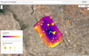
A new AI-powered satellite will create Google Maps for methane pollution
Methane emissions, be it from industrial cattle farming or fossil fuel extraction, are responsible for roughly 30 percent of the Earth’s climate change issues. But despite the massive amounts of methane emissions released into the atmosphere every year, it’s often difficult to track the pollutant—apart from being invisible to the human eye and satellites’ multispectral near-infrared wavelength sensors, methane is also hard to assess due to spectral noise in the atmosphere.
To help tackle this immediate crisis, Google and the Environmental Defense Fund are teaming up for a new project with lofty goals. Announced in a new blog post earlier today, MethaneSAT in a new, AI-enhanced satellite project to better track and quantify the dangerous emissions, with an aim to offer the info to researchers around the world.
“MethaneSAT is highly sophisticated; it has a unique ability to monitor both high-emitting methane sources and small sources spread over a wide area,” Yael Maguire, Google’s VP and General Manager of Geo Developer & Sustainability, said in a February 14 statement.
[Related: How AI could help scientists spot ‘ultra-emission’ methane plumes faster—from space.]
To handle such a massive endeavor, the EDF developed new algorithmic software with researchers at the Smithsonian Astrophysical Observatory andHarvard University’s School of Engineering and Applied Science and its Center for Astrophysics. Their new supercomputer-powered AI system can calculate methane emissions in specific locations, and subsequently track those pollutants as they spread in the atmosphere.
MethaneSAT is scheduled to launch aboard a SpaceX Falcon 9 rocket in early March. Once deployed at an altitude of over 350 miles, the satellite will circle the Earth 15 times per day at roughly 1,660 mph. Aside from emission detection duties, Google and EDF intend to harness their AI programs to compile a worldwide map of oil and gas infrastructure systems to hone in what aspects rank as the worst offenders. According to Google, this will function much like how its AI programs interpret satellite imagery for Google Maps. Instead of road names, street signs, and sidewalk markers, however, MethaneSAT will help tag points like oil storage containers.
“Once we have this complete infrastructure map, we can overlay the MethaneSAT data that shows where methane is coming from,” Maguire said on Wednesday. “When the two maps are lined up, we can see how emissions correspond to specific infrastructure and obtain a far better understanding of the types of sources that generally contribute most to methane leaks.” Datasets like these could prove valuable to watchdogs and experts attempting to rein in oil and gas emission locations that may become more prone to leaks.
All this much-needed information is intended to become available later this year through the official MethaneSAT website, as well as Google Earth Engine, the company’s open-source global environmental monitoring platform. In the very near future, the new emissions data will be able to combine alongside datasets concerning factors like waterways, land cover, and regional borders to better assess where we are as a global community, and what needs to be done in order to stave off climate change’s worst outcomes.
 Gettr
GettrPlease Support Our Sponsors

Solar Power Generator Discounts Along With Free Shipping
- 10% OFF for Jackery Solar Generator 2000 Pro Series with code "JADEAL"
- 10% OFF for Jackery SolarSaga 200W Solar Panel with code "JADEAL"
- 10% OFF for Jackery Solar Generator 1500 Series with code "JADEAL"
- 10% OFF for Jackery Solar Generator 1000 Series with code "JADEAL"
- 10% OFF for Jackery Explorer 1500 Portable Power Station with code "JADEAL"
- 10% OFF for Jackery Explorer 1000 Pro Portable Power Station with code "JADEAL"
- 10% OFF for Jackery Explorer 500 Pro Portable Power Station with code "JADEAL"
- 10% OFF for Jackery Explorer 300 Pro Portable Power Station with code "JADEAL"
- 10% OFF for Jackery SolarSaga 100W Solar Panel with code "JADEAL"


The University of Georgia is represented by the Georgia Bulldogs . The Bulldogs participate in the Southeastern Conference's (SEC) Eastern Division of the NCAA.
They play their home games in the storied Sanford Stadium in Athens, Georgia. The first season in Georgia was in 1892. In 1942, 1980, and 2021, the Georgia Bulldogs won three national championships.
The Georgia Bulldogs have additionally been crowned the National Champion in four additional seasons by at least one polling organization (1920, 1927, 1946 and 1968).
The Georgia Bulldogs are tied for second place in conference history with their 15 conference titles, including 13 SEC titles, and their 59 bowl appearances, which ranks second all-time.
In addition, the program has produced five top picks in the National Football League (NFL) draft, two Heisman Trophy winners, numerous winners of various national honors, and many others.

Longhorns football represents the University of Texas in Austin often known as Texas, UT or the Texas Longhorns. The Longhorns represent the Big 12 Conference in the NCAA Division. They play in Austin, Texas, at the Darrell K. Royal-Texas Memorial Stadium.
The Texas Longhorns are ranked third and seventh, respectively, in terms of all-time wins and win-loss records, with over 900 victories and an overall win-loss percentage of.705.
The legendary program also boasts four national titles, 32 conference titles, 100 First Team All-Americans, and two Heisman Trophy winners.
Get your Texas Longhorns Revival T-Shirt today. The Texas Longhorns Rustic Revival shirt is also a fan favorite.
Many college sports fans like to wear their gear all around town, get your Texas Longhorns Centered gear and show your support.